Project Overview
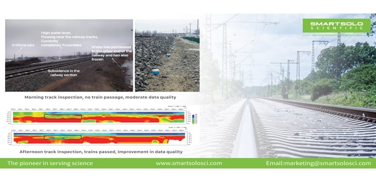
This project focuses on assessing the geological conditions beneath a coal transportation railway located in Tangshan City, Hebei Province. The presence of an artificial lake near the railway has led to water infiltration on the opposite side, causing subsidence. Future plans include grouting reinforcement to stabilize the affected areas.
Project Characteristics
The geological assessment employs a combination of advanced techniques to ensure comprehensive analysis:
- Geological Radar:
- Offers high-resolution imaging of subsurface structures.
- Identifies potential voids and weak zones beneath the railway.
- High-Density Electrical Resistivity Tomography (ERT):
- Maps subsurface resistivity variations to detect areas of water infiltration.
- Highlights zones of potential instability.
- Seismic Surface Wave Analysis:
- Provides information on the mechanical properties of subsurface materials.
- Assesses the depth and extent of affected zones.
Data Quality Comparison
The project’s analysis compares data from geological radar, electrical resistivity tomography, and passive seismic source methods. Key observations include:
- Passive Seismic Source Method:
- Exhibits higher efficiency in data acquisition.
- Achieves greater measurement depth compared to ERT.
- Delivers more precise assessments of geological conditions, enhancing the overall understanding of subsurface stability.
Conclusion
The integrated use of geological radar, ERT, and seismic surface wave analysis ensures a robust and accurate assessment of the railway’s geological status. The insights gained from this assessment will guide grouting reinforcement plans, ensuring the safety and reliability of the railway infrastructure in Hebei Province.