Project Overview
Earthquakes are increasingly frequent, posing relentless challenges and risks to human safety. Recognizing the critical need for scientific insight into seismic hazards, researchers have focused on studying geological structures in earthquake-prone areas to provide guidance for disaster prevention, mitigation, and resilient infrastructure development.
This study examines the 6.0 magnitude earthquake in Lu County, Luzhou City, Sichuan Province, which occurred on 16 September 2021. Researchers utilized data recorded by a dense seismic observatory array deployed with SmartSolo smart node seismometers to analyze the region’s three-dimensional (3D) S-wave velocity structure using background noise imaging methods. The findings provide valuable insights into velocity structure characteristics, seismic distribution, and the deep seismogenic environment of the earthquake region.
Methodology
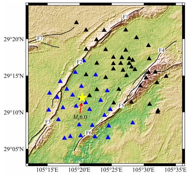
The Chengdu Tibetan Plateau Seismological Research Institute (CPTSRI) of the China Earthquake Administration deployed a total of 70 short-period seismic observation stations in two phases:
First Batch
- Setup: 40 seismic stations deployed northeast of the epicenter before the earthquake on 16 September 2021.
- Data Recording: Continuous waveforms recorded from 10 September to 22 October 2021.
- Key Findings:
- Successfully captured the mainshock and numerous aftershocks.
Second Batch
- Setup: 30 seismic instruments deployed southwest of the epicenter after the mainshock on 23 September 2021.
- Data Recording: Waveforms recorded from 23 September to 22 October 2021.
Key Results
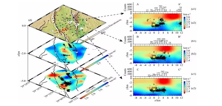
By processing the acquired seismic data and conducting Rayleigh wave inversion, the study achieved the following:
- High-Resolution 3D S-Wave Velocity Structure:
- Detailed mapping of the velocity structure in the Luxian seismic region.
- Seismic Distribution Analysis:
- Identified seismic clusters and their relationship to geological faults.
- Dynamic Seismogenic Environment:
- Improved understanding of the causal mechanisms behind the earthquake.
Significance of the Study
The results provide a scientific foundation for:
- Assessing Seismic Hazards: Evaluating potential risks and improving earthquake preparedness.
- Guiding Infrastructure Development: Ensuring resilience in seismic-prone regions.
- Closing Data Gaps: Addressing the lack of high-resolution geophysical data near the earthquake epicenter.
Conclusion
This study underscores the importance of using advanced technologies like SmartSolo seismometers for seismic research. The findings contribute to understanding earthquake mechanisms, mitigating risks, and guiding disaster prevention efforts. As scientists continue to explore the earth’s mysteries, advancements in seismic research will lead to safer and more sustainable futures.