Impact craters, or astroblemes, are some of the most captivating geological features in our solar system. On Earth, they serve as unique natural laboratories, providing a rare window into the composition and structure of materials subjected to the extreme pressures and temperatures typically found only in the deep planetary interiors.
Located in Heilongjiang Province, Northeast China (Figure 1), the Yilan Crater is only the second confirmed impact structure in the country. With a rim-to-rim diameter of 1.85 km, it is classified as a “simple” crater, featuring a distinctive crescent-shaped rim. While previous drilling revealed evidence of shock-melted granite and high-pressure minerals like coesite, the crater’s subsurface structure and the nature of the impact itself remained unexplored by geophysics—until now.
Figure 1. Location, Geological Setting, and Dense Seismic Array Deployment at the Yilan Impact Crater
In a pioneering study recently published in Communications Earth & Environment, a research team led by Yangfan Deng from the Guangzhou Institute of Geochemistry, Chinese Academy of Sciences, deployed an ultra-dense array of 220 SmartSolo nodal seismometers (Figure 2). This project represents the first time a novel passive-source seismic imaging approach has been applied to a terrestrial impact crater using such a dense grid. Between April and May 2023, the team utilised these three-component 5-Hz nodes to record natural ambient noise and local seismic events, mapping the subsurface in unprecedented detail across a 3 by 3 km target area.
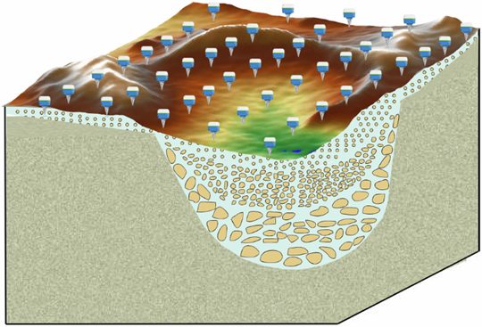
Figure 2. Dense Nodal Seismograph Array
The high-density data allowed the team to use multiple seismic methods, including ambient noise tomography and Horizontal-to-Vertical Spectral Ratio (HVSR) analysis.
- Three-Dimensional Structure: The analysis revealed a clear 3D bowl-shaped structure beneath the crater, characterised by the thickest low-velocity layer at the centre.
- Significant Site Amplification: The team identified a pronounced site amplification effect—with ground motion values ten times higher than surrounding areas—generated by the loose lacustrine sediments and fractured rocks (breccia) that fill the crater.
- Sediment Thickness: Using HVSR curves, the researchers estimated the sedimentary infill at the crater centre to be approximately 145 (+/- 20) meters thick, aligning perfectly with earlier drilling data (Figure 3).
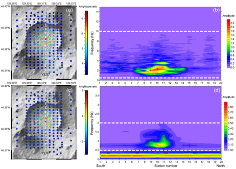
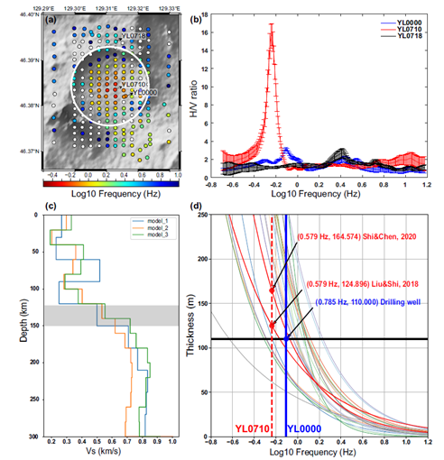
Figure 3. Amplitude ratios from the seismic observations at the Crater Centre (top) and HVSR information and velocity models (bottom)
To understand the event that created this structure, the team performed a parametric grid search using the Earth Impact Effects Calculator. Because estimating an impactor’s exact velocity and diameter from crater size alone is a complex challenge, the team focused on the “impact energy”—the residual kinetic energy released when the object struck the ground (Figure 4).
The results indicate that the impact energy reached approximately 1 X 10^17 Joules. This energy is equivalent to a magnitude 5.5 earthquake. To put this in perspective, while it is smaller than the catastrophic Chicxulub event, it is roughly 10 times the energy of the famous Barringer Crater impact in Arizona. This finding ranks the Yilan impact among the most significant events on Earth over the last 80,000 years.
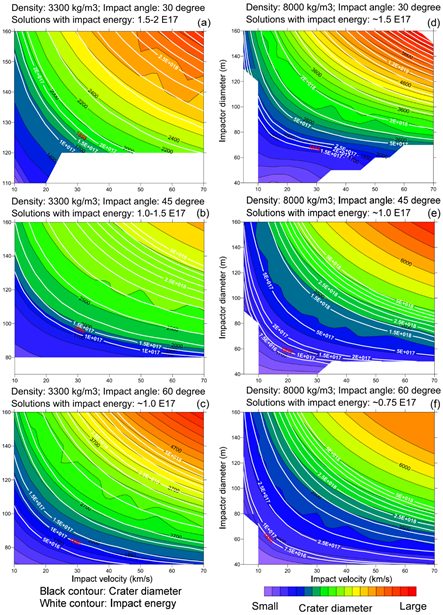
Figure 4. Crater Size and Energy Estimated by Simulating Variations in Projectile Density, Impact Angle, Impact Velocity, and Projectile Diameter
The study also provides a glimpse into the prehistoric environment. Carbon-14 dating of impact-produced charcoal suggests the event occurred roughly 49,300 years ago. Paleontological evidence, including mammoth fossils found in the region dating back 48,000 years, indicates that the Yilan area was a lush ecosystem at the time of impact. The massive release of energy is likely to have had a profound local or regional effect on this environment, underscoring the importance of further multidisciplinary research into the crater’s history Figure 5).
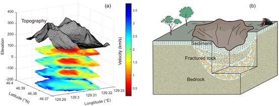
Figure 5. Three-Dimensional Subsurface Impact Structure of the Yilan Crater and a Schematic Illustration.
This research not only provides a geophysical blueprint of the Yilan impact but also demonstrates the power of ultra-dense nodal arrays for exploring Earth’s hidden history. We are proud to see SmartSolo technology at the forefront of such significant planetary science, helping researchers uncover the secrets of our world, node by node.
Read the full study: https://doi.org/10.1038/s43247-025-02274-5
Reference: Deng, Y., Bignardi, S., Zhang, Z. et al. Subsurface structure and impact process of Yilan Crater, northeastern China. Commun Earth Environ 6, 301 (2025). https://doi.org/10.1038/s43247-025-02274-5