Impact craters are fascinating geological features, offering unique insights into planetary science and Earth’s history. The Yilan Crater in Northeast China, recently confirmed as an impact structure, presents a compelling case study. While previous geological investigations have revealed evidence of a meteorite impact, a detailed understanding of its subsurface structure and the impact process has been limited. This is where advanced geophysical methods, particularly seismic exploration using modern seismic instruments like SmartSolo seismic nodes, play a crucial role.
Seismic Exploration at Yilan Crater: A New Perspective
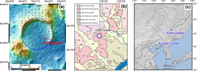
Traditional geophysical methods like gravity or magnetic surveys have been used to study impact craters. However, the application of passive seismic imaging with dense arrays offers a fresh perspective. To gain a deeper understanding of the Yilan Crater’s subsurface, a dense grid of 220 three-component 5-Hz SmartSolo seismic nodes was deployed in the spring of 2023. These seismic nodes were strategically placed to record natural seismic ambient noise, as well as local and distant earthquakes. This geophysical survey covered a 3×3 km area, with station spacing ranging from 150m to 300m, providing an ultra-dense observation network.
Site Amplification from Earthquake Recordings
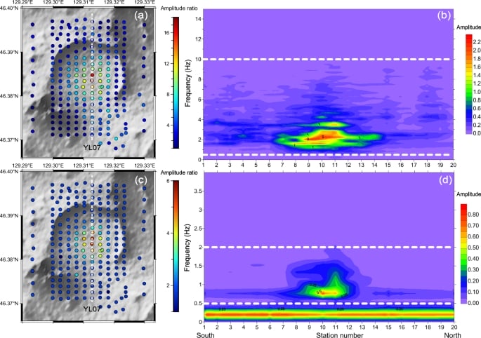
Analysis of earthquake recordings from both local and teleseismic events revealed significant ground motion amplification within the circular region of the crater. This amplification was particularly noticeable in the 0.5–10 Hz frequency range for local earthquakes and 0.5–2 Hz for teleseismic events. The observed amplification is attributed to the presence of loose sediment and impact-fractured rocks within the crater structure. The SmartSolo geophones, with their sensitive three-component recording capabilities, were instrumental in capturing these subtle variations in ground motion.
Subsurface Velocity Structure from Ambient Noise Tomography
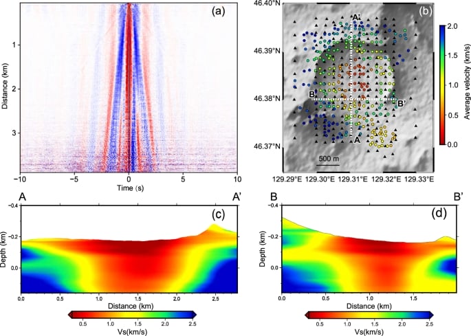
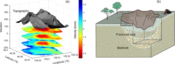
Ambient noise tomography, a technique that utilizes continuous seismic recordings to image subsurface structures, provided further insights into the Yilan Crater. By analyzing the cross-correlation functions of ambient noise recorded by the SmartSolo seismometers, researchers were able to map the seismic velocity structure beneath the crater. This low-velocity zone corresponds to the thick layer of lacustrine sediments and brecciated granite identified in previous drilling near the crater’s center.
Sediment Thickness Estimation from HVSR Analysis
The Horizontal-to-Vertical Spectral Ratio (HVSR) analysis of ambient noise provided an independent method for estimating the thickness of the sediment layer within the crater. This technique relies on the principle that the fundamental frequency of the HVSR curve is related to the thickness and shear wave velocity of the soft sediment layer overlying a harder bedrock. By analyzing the HVSR curves from the SmartSolo geophones deployed across the crater, researchers observed lower fundamental frequencies at the crater’s center, indicating a thicker sediment layer. Using empirical relationships calibrated with drilling data, the sediment thickness at the crater center was estimated to be around 145 ± 20 meters, aligning well with the results from ambient noise tomography.

Estimating the Impact Process
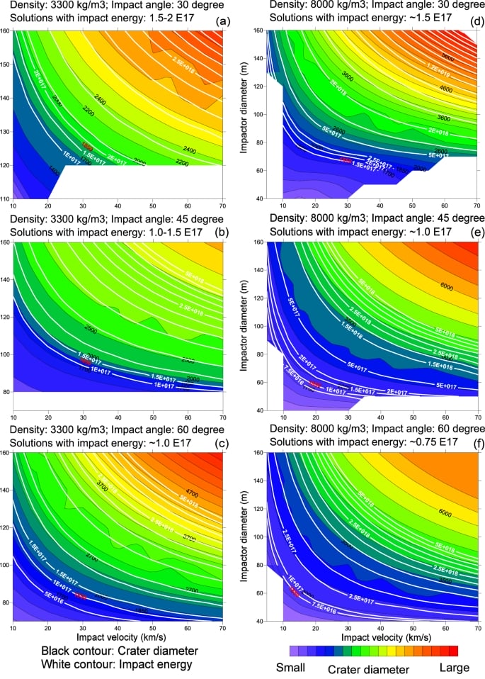
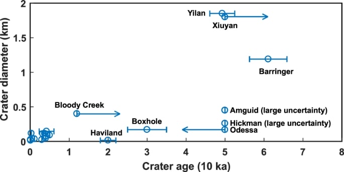
With a rim-to-rim diameter of 1.85 km and an estimated depth at the center of around 295 ± 20 meters, the Yilan Crater provides valuable data for understanding the impact event. By employing numerical modeling and considering various impactor parameters (diameter, velocity, density, and angle), researchers were able to constrain the characteristics of the impact that formed the crater. While multiple combinations of impactor size and speed could produce a crater of this diameter, the residual kinetic energy of the impactor upon striking the ground remained relatively consistent across plausible scenarios. The estimated impact energy is on the order of 1 × 10¹⁷ Joules. This energy is equivalent to a magnitude M5.5 earthquake, highlighting the significant scale of the Yilan impact event.
Implications and Future Research
The findings from this seismic investigation using SmartSolo seismic nodes offer valuable insights into the subsurface structure and impact process of the Yilan Crater. The observed seismic amplification and the revealed bowl-shaped structure are directly linked to the geological consequences of the impact. The estimated impact energy places the Yilan event among the strongest impacts on Earth in the last 80,000 years. This significant energy release likely had a considerable impact on the local and regional environment at the time, potentially influencing the living conditions of large mammals like mammoths, whose fossils have been found in the area.
This study underscores the power of dense seismic arrays and advanced seismic analysis techniques in characterizing impact structures. The use of SmartSolo seismic nodes facilitated the collection of high-quality data necessary for these detailed investigations. Future multidisciplinary studies, combining geophysical data with geological and paleontological evidence, are needed to fully understand the long-term environmental consequences of the Yilan impact event and its place in Earth’s impact history.
SmartSolo and Geophysical Breakthroughs
SmartSolo seismic nodes are at the forefront of modern geophysical exploration. Their ease of deployment, high sensitivity, and continuous recording capabilities make them ideal for a wide range of applications, including detailed studies of complex geological structures like impact craters. The success of the Yilan Crater investigation highlights the potential of these advanced seismic instruments to provide unprecedented insights into Earth’s subsurface and the processes that shape our planet.
Whether for earthquake monitoring, seismic survey, or understanding the effects of seismic waves, SmartSolo technology offers reliable and high-resolution data. The deployment at Yilan Crater demonstrates how dense arrays of geophones can unlock the secrets of geological features that were previously difficult to study in detail.
The study of impact craters is a critical aspect of understanding Earth’s history and the potential hazards posed by extraterrestrial impacts. By providing the tools for high-resolution seismic detection and imaging, SmartSolo contributes significantly to this important field of research.
For more information on SmartSolo seismic nodes and their applications in geophysical engineering and seismic activity monitoring, Please feel free to explore the SmartSolo website. And for more details of this case study, please visit Nature.com.