Project Background
In 2008, the Wenchuan earthquake caused extensive surface rupture zones in Beichuan’s old county town, increasing the region’s susceptibility to geological hazards such as:
- Landslides
- Subsidence
To address these risks, a short-period dense seismic array method was employed to investigate the area’s shallow crustal structure.
Project Overview
Methodology
This study utilized:
- Background Noise Tomography: To assess variations in subsurface wave propagation.
- Horizontal-to-Vertical Spectral Ratio (HVSR) Analysis: To detect shear wave anomalies and sedimentary layer properties.
Equipment Used
- 242 SmartSolo Seismic Node Instruments
Key Findings
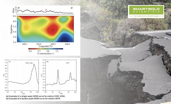
- Low-Velocity Shear Wave Zones: Identified three distinct anomalies, including one located approximately 2 kilometers beneath the surface rupture zone of the Wenchuan earthquake.
- HVSR Curve Features: Stations near the rupture zone displayed bimodal characteristics, while those farther away exhibited unimodal patterns.
- Sedimentary Layer Thickness: The maximum depth of sedimentary layers in the study area was found to reach 200 meters.
Conclusion
The research highlights the effectiveness of short-period dense seismic arrays and SmartSolo nodes in mapping shallow crustal structures. By identifying key subsurface anomalies, this study provides valuable insights for mitigating geological risks in earthquake-prone areas like Beichuan.