Introduction
Karst terrains, characterised by soluble rock such as limestone, present significant geohazards for urban development, infrastructure projects, and groundwater management. In rapidly growing cities like Shenzhen, China, accurately mapping shallow subsurface structures—including faults, fractures, and cavities—is essential for risk mitigation and engineering safety. A recent study conducted in the Pingshan district of Shenzhen successfully applied high-resolution seismic reflection surveying to delineate complex near-surface geology in a karst-prone area. This case study highlights how advanced seismic acquisition technology, including SmartSolo IGU-16HR 3C 5Hz nodal seismometers, enabled researchers to obtain clear subsurface images and improve the understanding of karst formation mechanisms.
Project Overview and Objectives
The study aimed to address several key challenges in karst geophysics:
- Testing seismic methods in karst terrain to evaluate their effectiveness in detecting voids and faults.
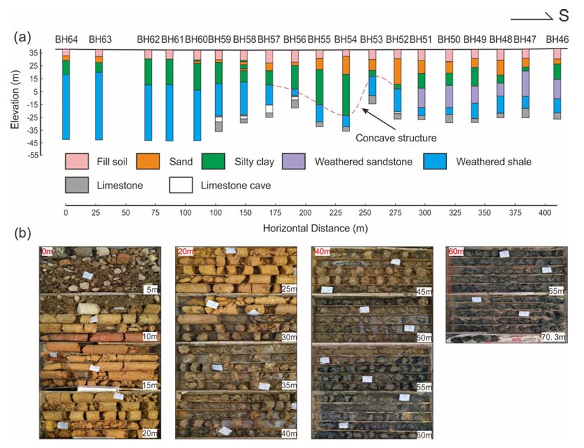
- Correlating seismic results with borehole data to validate interpretations.
- Integrating physical property measurements with synthetic seismic modelling.
- Providing insights into karst cave formation and distribution related to structural features.
Geological Setting
The survey area is located within the Carboniferous rock sequences of Shenzhen, which are characterised by karst features that are covered and buried. Previous drilling has revealed karst caves at depths of 2 to 50 meters, posing risks to construction and tunnelling projects. The presence of faults and fractured zones further increases the potential for groundwater-driven dissolution and cavity formation.
Data Acquisition: Methodology and Equipment
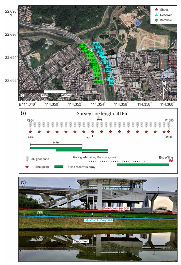
A high-resolution 2D seismic line, 417 meters long, was acquired in November 2022 along Longping Road in Shenzhen. The acquisition design emphasised high spatial sampling to resolve shallow geological structures:
- Source: A 5 kg sledgehammer striking a metal plate.
- Receivers: 148 SmartSolo IGU-16HR 3C 5Hz nodal units were deployed at 1-meter intervals.
- Geometry: An asymmetric split-spread roll-along geometry with 2-meter shot spacing, resulting in 417 receivers and 209 shot points.
- Recording Parameters: 1 ms sampling rate, 1-second record length.
Data Processing and Results
A comprehensive processing workflow was applied to enhance signal-to-noise ratio and imaging clarity, including:
- First-break tomography for near-surface static corrections.
- Band-pass filtering, spectral balancing, and linear noise attenuation to suppress airwaves, ground roll, and coherent noise.
- Iterative velocity analysis, residual statics, and pre-stack time migration.
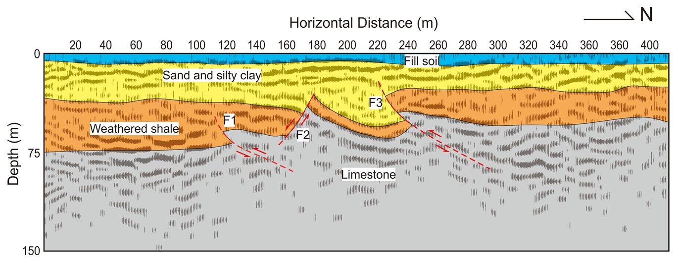
The final seismic section revealed:
- Four distinct layers: fill soil, sand/silty clay, weathered shale, and limestone bedrock, imaged down to 80–90 meters depth.
- Three interpreted faults (two thrusts and one normal fault) forming an upward-concave structure.
- Strong correlation between fault locations and borehole-detected karst caves, suggesting structural control on cave development.
Synthetic Modelling and Validation
A 2D elastic finite-difference model was constructed using measured P-wave, S-wave, and density values. The synthetic seismograms and migrated sections showed excellent correlation with field data, confirming the interpretation of key reflectors and the concave structure observed in the seismic image.
Interpretation and Implications
The study concludes that:
- Karst caves in the area are structurally controlled, developing along faults and fractures that provide pathways for groundwater infiltration.
- Dissolution by carbonic acid-enriched water from the nearby Ciao River contributes to cavity formation.
- The integration of High-resolution seismic reflection with borehole data is a powerful tool for identifying fault zones and potential karst hazards prior to construction.
Conclusion
This research demonstrates the effectiveness of high-resolution seismic reflection surveying for urban near-surface characterisation in karst regions. By integrating dense seismic data with borehole control and synthetic modelling, the team provided a reliable geological model that enhances understanding of karst development and supports engineering risk assessment.
The successful outcome of this project underscores the importance of using capable, adaptable, and high-fidelity seismic sensors in complex shallow geophysical investigations. The SmartSolo IGU-16HR 3C nodal system proved to be a reliable choice, delivering the data quality and operational flexibility needed to achieve the study’s objectives in an urban karst setting.
Reference: Wang, Z., Juhlin, C., Lü, Q., Ruan, X., Liu, Z., Yu, C., and Chen, M.: High-resolution seismic reflection surveying to delineate shallow subsurface geological structures in the karst area of Shenzhen, China, Solid Earth, 16, 761–773, https://doi.org/10.5194/se-16-761-2025, 2025.