Understanding Glacier Risks in the Sedongpu Valley
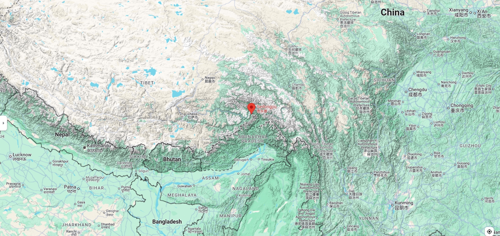
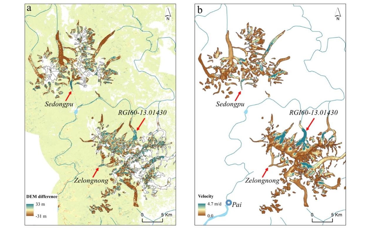
The Sedongpu Valley, located in southeastern Tibet, is at high risk for glacier-related disasters. This region has many temperate glaciers that are close to melting throughout the year. It is part of the Namcha Barwa-Gyala Peri massif, known for its steep hills and tectonic activity.
Heavy rainfall during the monsoon season can cause ice and rock to collapse, which in turn leads to hazardous debris flows. These flows can block the Yarlung Tsangpo River, threatening nearby communities, including the town of Pai, which has over 3,000 residents and significant hydropower projects.
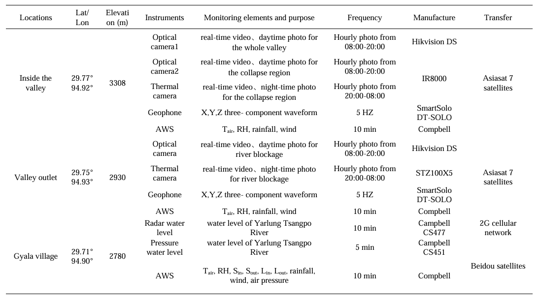
To address these dangers, researchers have set up a Glacier Early Warning System (EWS) in the Sedongpu Valley. This system features various monitoring stations that utilize advanced technologies, including SmartSolo nodes. These nodes are essential geophysical tools that track seismic activity and offer alerts for potential disasters. The EWS has three main components, each focusing on different aspects of glacier behaviors and seismic activities.
Key Components of the Early Warning System
EWS1: Ice-Rock Collapse Detection
The first component, EWS1, is situated in the Sedongpu Valley. Its primary goal is to detect ice-rock collapses. In May 2022, a 4-meter-high observation tower was constructed at an elevation of 3,308 meters. This tower station employs SmartSolo nodes and geophones to monitor seismic activity related to ice and rock movements. Due to the challenging access, helicopters were used to deliver the equipment. EWS1 is crucial for collecting data about seismic events and understanding the geophysical dynamics of the valley.
EWS2: Monitoring Debris Flows
The second station, EWS2, is located near the outlet of the Sedongpu Valley. It monitors seismic activity related to debris flows and potential river blockages. In October 2019, a 10-meter observation tower was built here, but it was destroyed by a massive collapse in March 2021. To prevent similar damage, EWS2 was rebuilt upstream in May 2021. SmartSolo nodes at this station help researchers analyze the seismic details of debris flow events, providing important information for earthquake monitoring.
EWS3: Water Level Tracking
The third component, EWS3, is located at Gyala village, about 6 kilometers upstream from the Sedongpu basin. This station focuses on monitoring water levels in the Yarlung Tsangpo River to provide early warnings of possible blockages. By tracking changes in water levels, researchers can predict hazards related to glacier movements and seismic activity.
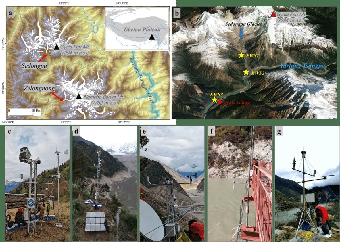
(a) Glacier distribution around the Mt. Namcha Barwa and the Mt. Gyala Peri in the southeastern Tibetan Plateau with the Sedongpu Glacier and Zelongnong Glacier;
(b) © Google Earth image showing the 3D topography of the Sedongpu Valley and the locations of three early warning systems: EWS1-3 (yellow stars); (c) the EWS1 inside the Sedongpu Valley for ice collapse observations;
(d) the EWS2 of the 10 m observation tower, which was installed near the Sedongpu Valley outlet but was destroyed by the massive ice-rock collapse on 22 March 2022;
(e) the rebuilt EWS2 near the Sedongpu Valley outlet to warn the blockage of the Yarlung Tsangpo River;
(f, g) the EWS3 of the radar water level sensor and the automatic weather station (AWS) with pressure water level sensor near the Gyala village.
Instruments in the Early Warning System
Each EWS station is equipped with several instruments to create a clear picture of what is happening in the area.
SmartSolo Nodes and Geophones
SmartSolo nodes are equipped with sensitive seismic sensors that detect subtle ground vibrations caused by ice-rock collapses. These real-time seismographs collect the data for analysis day and night. They are particularly important in high-altitude areas where clouds can limit visual monitoring.
Built to be tough and reliable in harsh environments, SmartSolo nodes help researchers understand the seismic impact of collapse events and track geological changes in the region.
Optical and Thermal Cameras
The EWS also includes optical and thermal cameras for visual monitoring of the Sedongpu Valley and the Yarlung Tsangpo River. These cameras capture images of collapse events, debris flows, and river blockages. Hourly photos are sent to a server, and videos are saved for later review. This visual data complements the seismic information collected by SmartSolo nodes and geophones.
Water Level Sensors
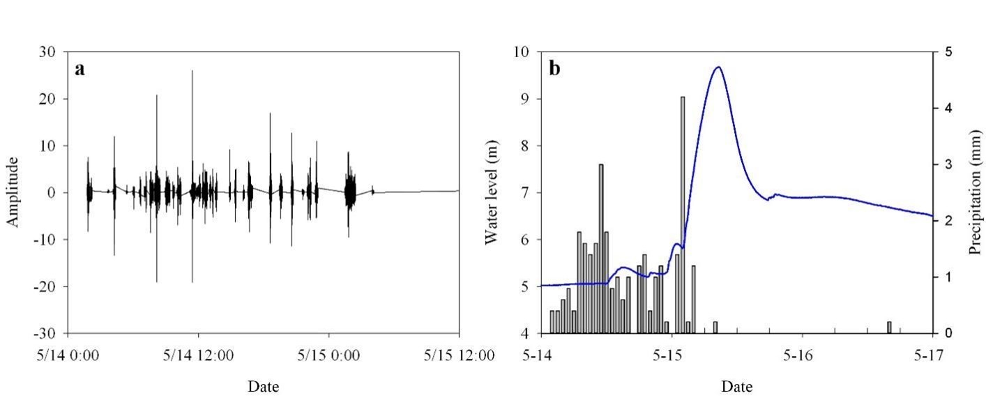
At the EWS3, water level sensors monitor changes in the Yarlung Tsangpo River’s levels. A sudden rise may indicate a blockage caused by debris flow. There are two types of sensors: radar sensors which check levels every 10 minutes, and pressure transducer sensors which check every 5 minutes. This dual system ensures reliable detection of potential hazards.
Meteorological Stations
Meteorological stations are also part of the EWS, collecting important weather data such as air temperature, humidity, rainfall, wind speed, and solar radiation. This information helps researchers understand the weather conditions that can lead to ice-rock collapses and debris flows. By combining weather data with seismic and visual monitoring, the EWS provides a more complete picture of risks in the area.
Success Cases of the Early Warning System
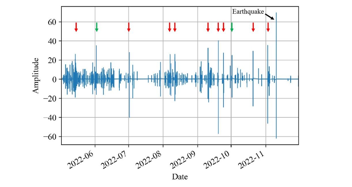
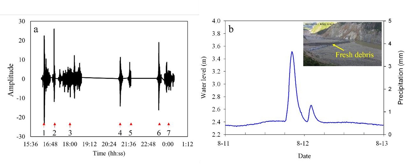
Data from the SmartSolo nodes have been crucial in identifying ice-rock collapses. Researchers found that a seismic waveform amplitude over 20 recorded by the EWS1 nodes typically indicates a collapse event that could lead to a debris flow. Additionally, the nodes can differentiate between seismic signals from ice-rock collapses and earthquakes which are common in this active region. This capability is vital for avoiding false alarms and ensuring the warning system is accurate.
Between May and December 2022, the nodes detected 12 events with amplitudes over 20 in the Sedongpu Valley. Further investigations confirmed that nine of these events led to debris flows reaching the valley outlet. These results demonstrate that SmartSolo nodes and geophones are effective tools for monitoring glacier-related dangers. While visual monitoring can be limited by weather, the nodes can pick up ground vibrations from a collapse even when visibility is poor.
Impact on Local Communities
The EWS has already proven its value by successfully detecting several ice-rock collapses and river blockages. By providing timely warnings, it has allowed local authorities to take action to evacuate people and reduce the potential impact of these disasters. The EWS is an excellent example of how science and technology can work together to solve real-world problems, thereby protecting lives and livelihoods in vulnerable communities.
the Future of EWS
Given the success of the Sedongpu Valley EWS, researchers recommend setting up similar systems in other high-risk glacier areas on the Tibetan Plateau. This proactive approach is critical for adapting to the changing glacial landscape and protecting communities and vital infrastructure from the increasing threat of glacier-related disasters. By investing in these early warning systems, we can better prepare for and respond to the challenges posed by climate change and natural hazards.
With ongoing research and development, the EWS can continue to improve, providing even more reliable data and alerts to safeguard communities against glacier-related hazards.