Survey Overview
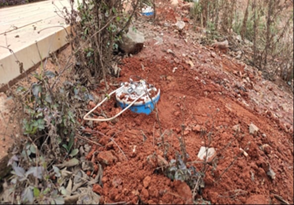
In preparation for the construction of a pipeline, a detailed geophysical survey was conducted in an area covered by gravel and soil. The primary goal was to identify underground structures, particularly karst formations, that could impact the pipeline’s integrity.
Survey Line and Borehole Data
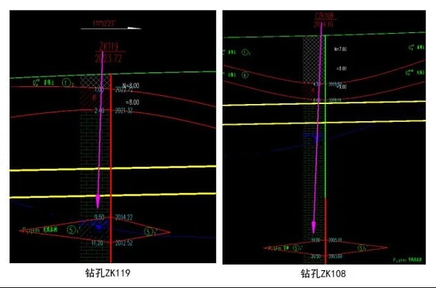
The survey focused on a specific area where the pipeline was planned to be laid. The survey line was strategically placed near two existing boreholes:
- ZK119: Revealed a filling-type karst cave at 9.5 meters depth (112 meters mark).
- ZK108: Uncovered a cavity karst cave at 19 meters depth (155 meters mark).
These boreholes offered initial insights into the presence of karst caves, which were crucial for further mapping and pipeline planning.
Microtremor Method for Enhanced Underground Profiling
To gather more detailed information, a Microtremor Method test was performed. This technique provides valuable data on the shear-wave velocity of underground strata, which can reveal anomalies such as karst caves.
Equipment and Setup
- SmartSolo IGU-BD3C-5 three-component seismic sensors (20 units) were used in a linear array, spaced 2 meters apart.
- The survey line covered approximately 210 meters in length.
- A high-density electrical test was also conducted along the same line at a 3-meter point interval to complement the seismic survey.
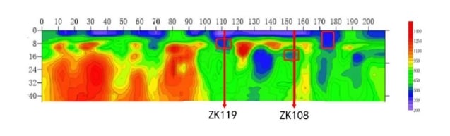
Key Findings from the Survey
1. Karst Cave Positions and Depths
The data obtained from the microtremor method confirmed the location and depth of karst caves identified by the boreholes. Additionally, new features were detected:
- New Vertical Karst Cave: Found at the 176-meter mark, with the shear-wave profile confirming its presence.
- Vertical Cracks: The cracks extended down to 8 meters, suggesting a potential risk for the pipeline route.
2. Enhanced Accuracy with Microtremor Method
Compared to borehole data, the microtremor method offered more accurate and continuous information:
- Clearer Representation: The method provided a full-profile view of the karst formations, showing their distribution and vertical development.
- Full Underground Profile: Unlike boreholes, which offer localized data, the microtremor method provided a continuous understanding of the underground structure.
- Effective in Sparse Drilling Areas: This method proved valuable in areas where drilling was sparse or difficult, overcoming the limitations of traditional boreholes.
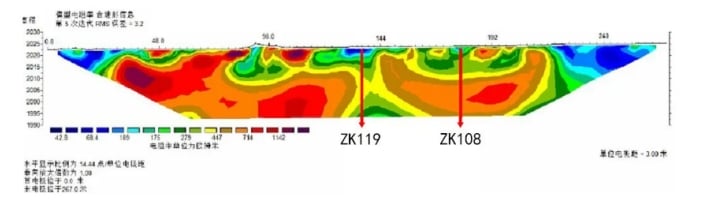
3. Synergy Between Electrical and Microtremor Methods
Combining the high-density electrical method with the microtremor technique resulted in more reliable results:
- Better Quantification: The microtremor method offered a more precise and semi-quantitative view of the karst formations.
- Increased Survey Confidence: The synergy between both methods provided more comprehensive and trustworthy data for planning.
4. Practical Application for Pipeline Construction
The microtremor method proved beneficial in several ways for pipeline construction:
- Effective in Drilling-Limited Areas: The method detected karst formations in areas where traditional drilling was not feasible.
- Vertical Development Insights: Understanding the vertical development of karst features was crucial for planning construction techniques like pipe jacking.
- Risk Mitigation: The survey helped identify potential risks in advance, allowing the construction team to prepare for unexpected underground features.
Conclusion
The microtremor method and high-density electrical method together proved to be a powerful combination for detecting and mapping karst formations before pipeline construction. These methods offered clear advantages over traditional drilling, including providing more detailed, continuous, and accurate data on underground features.
By revealing the positions, depths, and vertical development of karst caves, the methods helped ensure a safer and more reliable pipeline construction process. They also identified critical risks, such as the vertical cracks that could severely affect the pipeline’s integrity, allowing the construction team to mitigate potential issues early on.
The success of this survey highlights the value of the microtremor method in geophysical investigations, showing that it can complement or even surpass traditional drilling techniques in providing a comprehensive and accurate view of complex underground structures like karst caves.