Project Overview
Comprehensive geophysical surveys, including magnetotellurics, seismic, and airborne gravity magnetism, are essential to understanding the tectonic history of Antarctica. While these methods provide valuable data, they often lack the resolution needed to analyze the ice sheet and uppermost crustal structures in detail. Ice-penetrating radar, though capable of delivering high-resolution images of ice sheet reflectivity, cannot adequately constrain the physical properties beneath the ice—key to unlocking geological insights about the Antarctic continent.
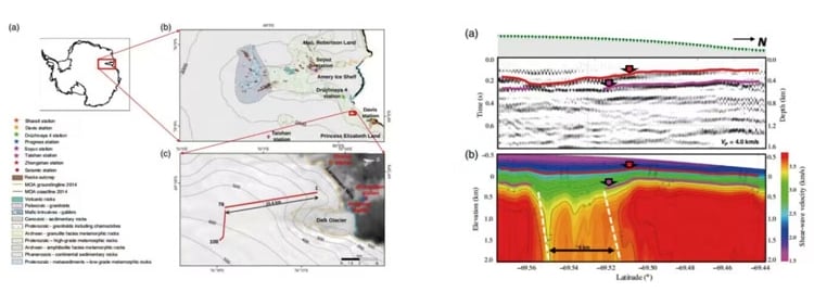
To overcome these limitations, scientists conducted an environmental noise seismic experiment using 100 SmartSolo short-period seismometers. The seismometers were deployed in a dense linear array with a spacing of 0.2 kilometers. This innovative setup targeted the Rasman Hills region in Prydz Bay, East Antarctica, aiming to produce high-resolution images of the ice sheet and the underlying upper crustal structure.
Equipment Used
- SmartSolo Node Seismometers: 100 short-period sensors spaced at 0.2-kilometer intervals.
Study Objectives
The primary goals of this study include:
- Detecting near-vertical ice-covered intrusions with a horizontal extent of up to 4 kilometers.
- Producing detailed images of the ice sheet and upper crustal structures beneath the Rasman Hills.
- Enhancing our understanding of the subglacial environment and the geological evolution in Prydz Bay.
Key Insights
This groundbreaking research, the first of its kind in Antarctica, highlights the potential of dense linear array imaging for:
- Mapping Subglacial Intrusions: Identifying geological features hidden beneath thick layers of ice.
- Improving Geological Models: Providing new data to refine our understanding of the tectonic processes shaping East Antarctica.
- Advancing Geophysical Techniques: Demonstrating the efficacy of environmental noise seismic experiments using SmartSolo seismometers in extreme environments.
Significance of the Study
The findings from this research will contribute significantly to:
- Unveiling the geological history of the Antarctic continent.
- Enhancing our understanding of subglacial geological formations in Rasman Hills.
- Supporting future studies that rely on high-resolution geophysical imaging for polar research.
Conclusion
This innovative application of dense linear array imaging using SmartSolo seismometers marks a significant step forward in Antarctic geophysical research. By achieving high-resolution insights into the ice sheet and upper crustal structures, the study paves the way for deeper explorations into the geological mysteries of East Antarctica.