Introduction
The Curnamona Province in southern Australia is a 90,000 km² Paleoproterozoic to Mesoproterozoic craton with significant mineral potential, including hosting the world-renowned Pb-Zn-Ag deposit at Broken Hill. Despite its geological importance, much of the region remains an exploration “greenfield” due to pervasive sedimentary cover ranging from a few meters to several kilometres in thickness. This paper details a major passive seismic study that utilised an extensive array of three-component nodal seismometers to perform Ambient Noise Tomography (ANT), aiming to map the deep crustal architecture and shear-wave velocity (Vs) signatures to a depth of 20 km.
Challenge
The primary challenge addressed by the study was the difficulty of imaging deep crustal structures in a remote, logistically demanding environment characterised by thick sedimentary sequences. Traditional seismic arrays typically require deployment periods of a year or more to collect sufficient data for high-resolution imaging. In the northern Curnamona Province, where land access is limited and deployment often requires helicopter support, such long-term projects are prohibitively expensive and time-consuming. The researchers aimed to determine the feasibility of achieving high-quality crustal imaging using a widespread array with a significantly shorter recording window of just 30 days.
Solution
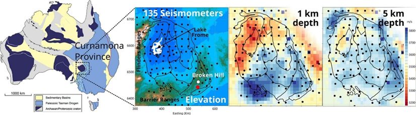
To overcome these logistical hurdles, the project deployed 135 SmartSolo IGU-16HR 3C three-component nodal seismometers. These units were co-located with broadband Magnetotelluric (MT) sites, creating a comprehensive geophysical grid with an average station spacing of approximately 25 km. The nodes operated at a sample rate of 2 ms and a natural frequency of 5 Hz, recording continuously for 30 days during June-July 2022. The “plug-and-play” nature of the SmartSolo nodes enabled efficient deployment in rugged terrain, including areas accessible only by helicopter, ensuring that a single collection cycle was sufficient to capture the necessary ambient noise data.
Results
The data collected by the SmartSolo nodes enabled the construction of a detailed 3D shear-wave velocity model that provided new insights into the province’s subsurface:
- Sedimentary Mapping: Low shear-wave velocities (<3400 m/s) in the top 5 km clearly delineated Neoproterozoic to Quaternary sedimentary basins, such as the Moorowie Basin, correlating closely with low electrical resistivity (<100 Ohm.m).
- Deep Crustal Architecture: The model resolved velocity gradients in the mid-crust (5–20 km), identifying a west-to-east increase in velocity of approximately 200 m/s across the southern province.
- Lithospheric Features: The survey identified a zone of lower shear-wave velocity (<3600 m/s) coincident with high-conductivity zones, interpreted as deeply buried graphitic Paleoproterozoic sediments linked to ancient continental sutures.
- Volcanic Identification: The high-velocity signature of the Benagerie Ridge Volcanics was successfully mapped, even where it potentially obscured underlying features.
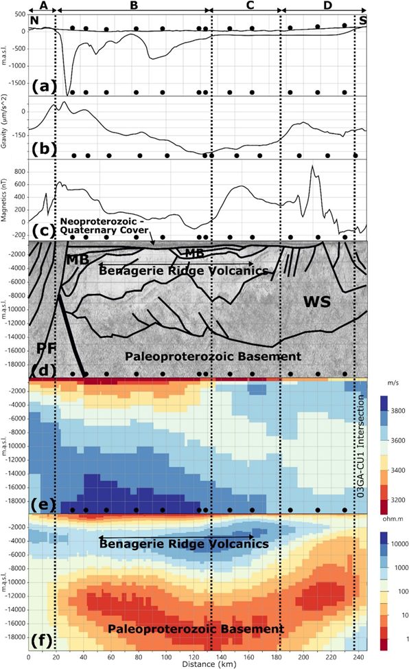
Figure 1. (a) Elevation (upper black line) and depth to Proterozoic basement (lower black line); (b) Bouguer gravity; (c) total magnetic intensity reduced to the pole; (d) migrated reflection seismic survey 08GA-C1 to 20 km depth with interpretation from Korsch et al. (2010); (e) shear-wave velocity model along 08GA-C1; (f) Resistivity along 08GA-C1 from Kay et al. (2022). Black circles show the location of passive seismometers and MT sites.
Significance
This case study underscores the effectiveness of SmartSolo nodal technology in high-stakes, greenfield exploration projects where traditional cabled systems or long-term deployments are impractical. By delivering high-quality, three-component data in just 30 days, the SmartSolo nodes demonstrated that rapid, high-density surveys can resolve complex crustal structures at depths previously difficult to image. The successful integration of nodal seismic data with MT and gravity models highlights the importance of utilising advanced, portable equipment to de-risk exploration in remote regions and to improve understanding of lithospheric architecture for mineral targeting.
Reference: Xin Tan, Yingjie Yang, Graham Heinson, Ben Kay, Goran Boren, Xiaozhou Yang, Crustal structure of the Curnamona Province in Australia by ambient noise tomography, Tectonophysics, Volume 906, 2025, 230737, ISSN 0040-1951, https://doi.org/10.1016/j.tecto.2025.230737.