Introduction
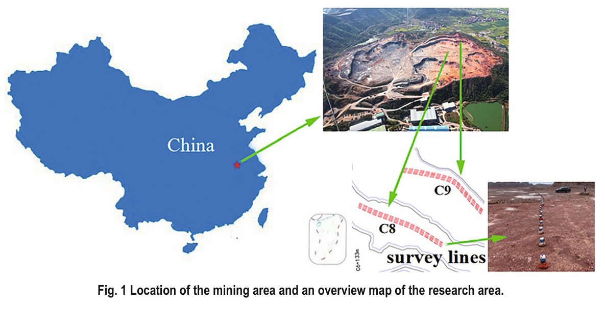
This case study showcases a pioneering application of passive seismic technology to advance “geological transparency” in open-pit mining. Conducted at the Fenghuang Mountain limestone mine in China, the research aimed to accurately and non-invasively map shallow subsurface cavities and loose zones within the rock mass. Such precise imaging is critical for optimizing intelligent blasting plans, preventing safety hazards from hidden voids, and enhancing overall mining efficiency.
Challenge: Overcoming the Limitations of Traditional Exploration in Active Mines
Conventional subsurface investigation methods, such as isolated borehole drilling or ground-penetrating radar (GPR), face significant challenges in active, wet mining environments. They are often point-based, inefficient, disruptive to operations, and ineffective in water-saturated conditions. The core challenge was to develop a rapid, continuous, and high-resolution imaging technique capable of detecting adverse geological structures up to 25 meters deep directly from the mining benches, without halting production.
Solution: Deploying a High-Density Linear Array for Ambient Noise Tomography
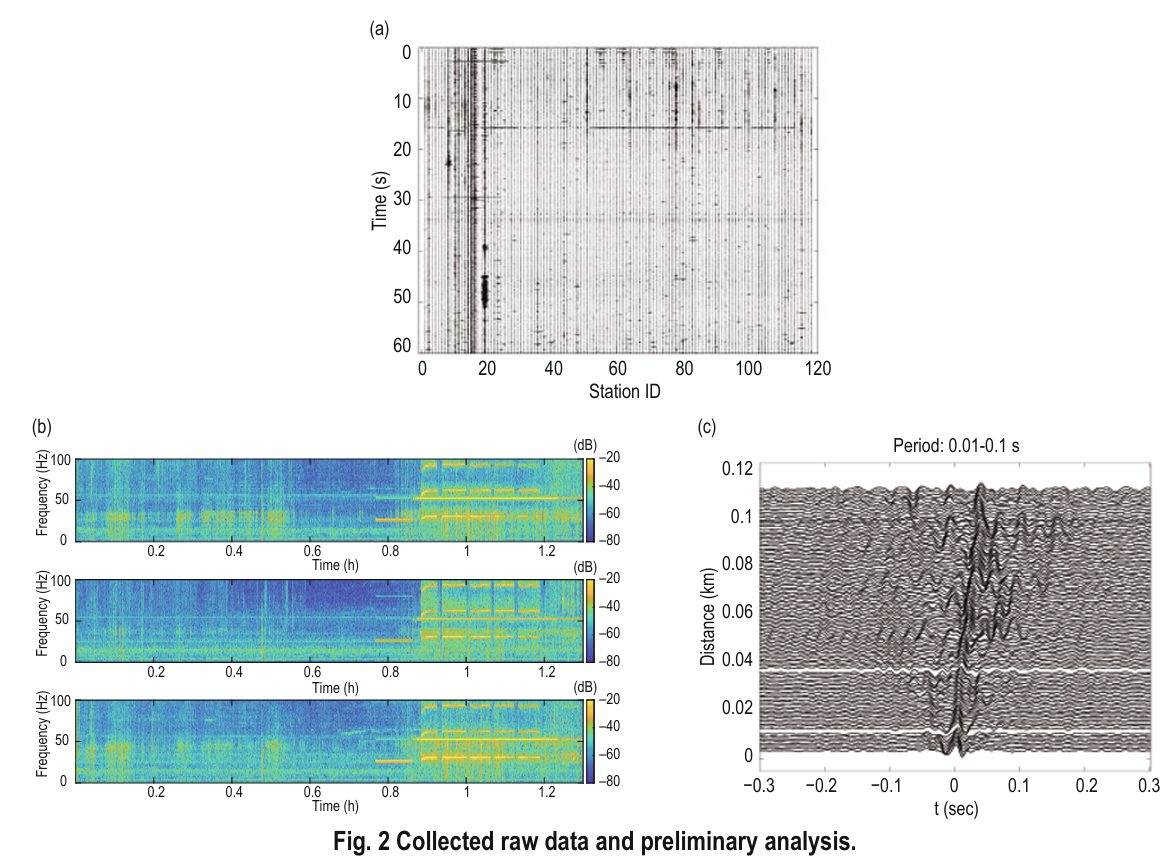
To overcome these hurdles, the research team implemented an innovative solution centered on ambient noise surface-wave seismic imaging. The key components were:
- High-Density Array Deployment: Installation of an ultra-dense, linear array of 120 SmartSolo IGU-16HR 5Hz nodal seismometers along the C8 and C9 mine platforms, with sensors spaced only 1 meter apart.
- Advanced Methodology: Processing of the continuously recorded ambient vibrations utilized two core techniques:
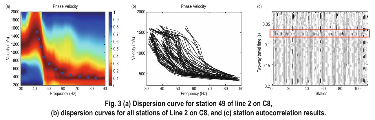
- Station Autocorrelation: Applied to the continuous records from individual nodes to retrieve the shallow subsurface reflection response directly beneath each sensor.
- Spatial Autocorrelation (SPAC): Utilized the dense array data to extract surface-wave dispersion curves for shear-wave velocity inversion and imaging.
- Critical Data Foundation: The deployment of the reliable and sensitive SmartSolo nodal systems was fundamental, providing the high-fidelity, continuous data stream required for robust tomography in a challenging, rainy operational environment.
Results: Clear Identification and Validation of Subsurface Hazards
The high-quality data yielded definitive and actionable outcomes:
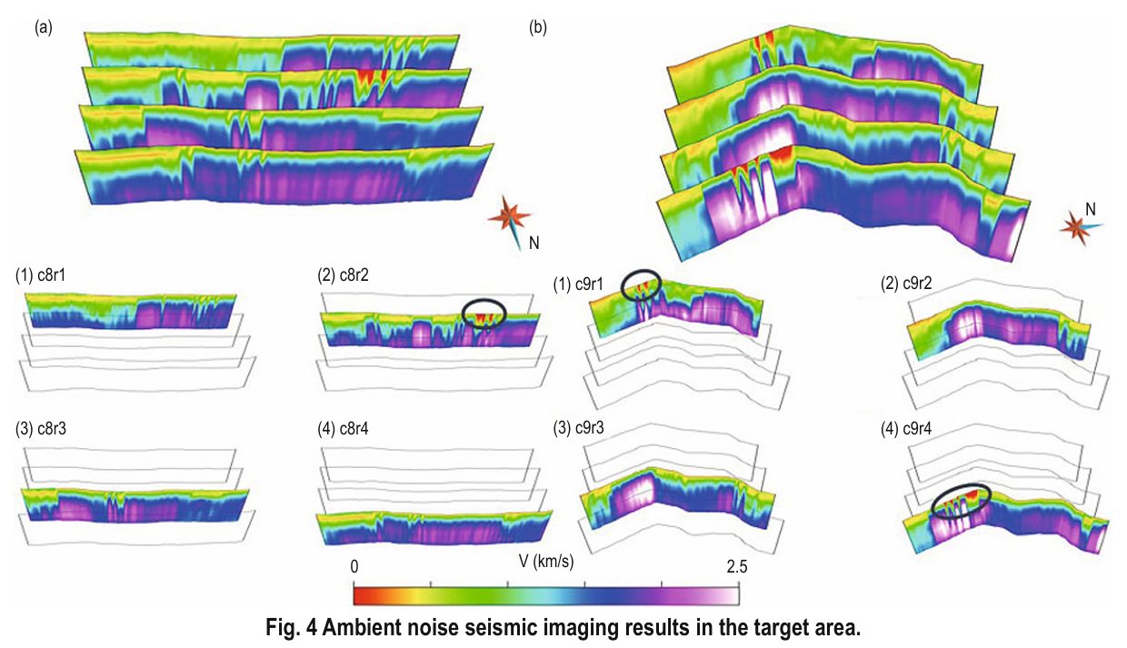
- Precise Hazard Mapping: Processed data generated high-resolution shear-wave velocity images, successfully pinpointing three distinct cavities or loose zones as clear low-velocity anomalies.
- Field Validation: Subsequent direct inspection and targeted drilling at the predicted locations confirmed the accuracy of the seismically identified structures.
- Quality-Driven Clarity: The consistency and quality of data from the SmartSolo array were key to producing clear, interpretable velocity models that enabled confident decision-making.
Significance: A Practical, Real-Time Tool for Intelligent Mining Safety
This project demonstrates that high-density ambient noise seismic imaging is a transformative, practical tool for real-time geological exploration in open-pit mines. It provides a fast, accurate, and non-disruptive method to visualize subsurface risks, directly informing safer and more efficient intelligent blasting designs. The success of this method hinged on the operational robustness and data quality of the nodal seismic system, proving the SmartSolo solution’s vital role in enabling next-generation, data-driven mining safety and transparency.
Reference: Li, PF., Zheng, QQ., Xu, Y. et al. Transparent geological exploration for intelligent and safe open-pit mining based on ambient noise seismic imaging. Appl. Geophys. 22, 12–21 (2025). https://doi.org/10.1007/s11770-024-1168-6