
Introduction:
This article highlights the critical role of seismic nodal technology in glaciology and hazard mitigation. The research focused on the Tête Rousse Glacier in the Mont-Blanc massif, French Alps. This small polythermal glacier is infamous for a catastrophic Glacial Lake Outburst Flood (GLOF) in 1892, which devastated the town of Saint-Gervais and killed 175 people. Since a new water-filled cavity was discovered in 2007, continuous geophysical monitoring has been essential to prevent future disasters. The primary objective of the May 2022 seismic campaign was to characterise known cavities better and detect any new, critical water-filled reservoirs that posed an imminent flood threat.
Challenge: Mapping Dynamic, High-Risk Englacial Hydrology
The central challenge was the non-invasive, high-resolution detection and location of potentially vast, hidden water volumes accumulating in the upper part of the glacier. Tête Rousse Glacier’s complex, polythermal structure—with a cold tongue that prevents subglacial water flow—leads to internal water accumulation, forming unstable englacial cavities. Prior geophysical surveys (GPR, SNMR) had suggested the presence of a new reservoir. Still, a real-time, spatially dense method was needed to confirm and pinpoint the source of this risk for rapid mitigation. Glacial seismic tremor, often generated by hydraulic processes, was identified as the ideal non-invasive target to find these hidden water bodies.
Solution: SmartSolo’s High-Density, Three-Component Nodal Array
To address this critical monitoring need, the research team deployed a dense seismic network utilising the SmartSolo IGU-16HR three-component seismic nodes.
- Equipment: 60 SmartSolo IGU-16HR 3C nodes were installed.
- Sensor Specifications: The nodes featured a 5 Hz resonance frequency.
- Acquisition Rate: The signal was sampled at either 500 Hz or 1,000 Hz across the network to capture high-frequency activity.
- Deployment Strategy: The array was deployed across the entire glacier for a three-week acquisition period (May 3–22, 2022). The density was exceptionally high, with sensors spaced at approximately 25 m.
- Methodology: This nodal network was used for both active and passive seismic studies. For passive monitoring, density was essential for detecting and locating faint, continuous, high-frequency harmonic tremor (20–200 Hz) likely generated by internal water flow and pressure changes. Localisation was achieved efficiently using both the classical P- and S-wave arrival-time picking method and the rapid amplitude-decay localisation method.
Results: Precision Location of a Water-Filled Reservoir
The SmartSolo network successfully captured a distinct seismic signal and enabled high-precision localisation, leading directly to the discovery of a new hazard:
- Tremor Detection: High-frequency harmonic tremor, with a fundamental resonance frequency of 23 Hz, was detected starting on May 15, 2022. The tremor amplitude was strongly correlated with the daily increase in water level in a nearby crevasse, confirming the signal’s link to meltwater infiltration.
- Localisation: Both the amplitude decay and arrival time methods provided a similar, convergent location for the tremor source, pinpointing it near the northern boundary of the glacier, close to the bergschrund.
- Subsurface Confirmation: The seismic results were definitively validated two years later. Ground Penetrating Radar (GPR) surveys (May 2024) and subsequent deep boreholes (October–November 2024, reaching up to 70m) confirmed the presence of a water-filled reservoir exactly at the location identified by the SmartSolo network. One borehole drilled near the source location reached water at a depth of 14.5 m, validating the nodal seismic result.
Significance: Essential Role of High-Density Nodal Technology
This project underscores the absolute necessity of utilising advanced, high-density seismic technology for the non-invasive, continuous monitoring of complex, high-risk glaciological environments. The ability of the SmartSolo nodes to operate in an unstable glacier environment with a dense 25-meter spacing was critical, as the faint harmonic tremor was detectable only by sensors within about 20 meters of the source. This high-resolution deployment enabled the use of a precise yet straightforward amplitude-decay localisation method, which is fast and easy to apply for real-time monitoring. The resulting confirmed location highlights the effectiveness of SmartSolo nodal systems in detecting hidden subsurface structures, such as water-filled cavities, providing crucial, actionable data for GLOF risk mitigation and ultimately saving lives.
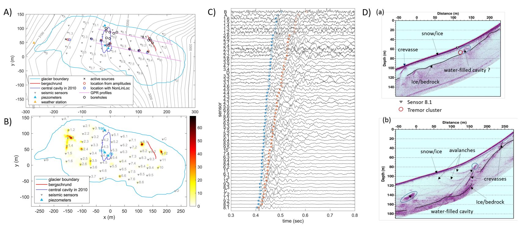
Figure 1. A) Map showing seismic network, piezometers, weather station and boreholes drilled in 2025. B) Map of background seismic sources estimated from amplitude decay for each 1-minute-long time window from 4 to 22 May. The colour scale represents the density of source points per m². C) Seismograms at all sensors. Picks of P and S waves are shown as blue and red dots, respectively. D) GPR migrated profiles after topography corrections. (a) L2, (b) L4.
Reference: Helmstetter, A., Garambois, S., Thibert, E., & Gagliardini, O. (2025). High‐frequency harmonic tremor associated with a water‐filled crevasse at Tête Rousse glacier, Mont‐Blanc massif. Journal of Geophysical Research: Earth Surface, 130, e2025JF008506. https://doi.org/10.1029/2025JF008506